Aton Announces Further Drill Intersections From Rodruin, Including 38m @ 1.84 G/t Gold From Surface
Vancouver, October 16, 2018: Aton Resources Inc. (AAN: TSX-V) (“Aton” or the “Company”) is very pleased to update investors with further exploration results from the Rodruin prospect, including assay results from drill holes ROP-004 to ROP-007 completed during the ongoing reverse circulation percussion (“RC”) drilling programme. Rodruin is located within the Company’s 100% owned Abu Marawat Concession (“Abu Marawat” or the “Concession”), located in the Eastern Desert of Egypt.
Highlights:
- Assay results are now available from RC drill holes ROP-004 to ROP-007, testing gossan-hosted mineralisation on the margins of Aladdin’s Hill at Rodruin. Drill hole ROP-004 has returned a mineralised intersection of 38m @ 1.84 g/t Au from surface;
- Drill holes ROP-005 to ROP-007 all had to be abandoned at less than 10m depth after intersectinglarge ancient underground workings, but all 3 holes intersected gossan-hosted mineralisation at orvery near to surface, including 2m @ 8.92 g/t Au (hole ROP-008) from 8m depth, prior toabandonment;
- RC drilling is continuing, as is drill access road and pad construction. Drill roads and pads have beencompleted in the Spiral Pit and Central Buttress areas, in the process exposing additional gossan-hosted mineralisation. Aton is continuing to actively open up mineralisation for drill testing over largeareas of the South Ridge at Rodruin.
“These results continue to demonstrate the extent of the mineralised area around Aladdin’s Hill and the fact that mineralisation extends below surface to depth. It also shows the potential of the large amount of ancient workings that we have identified and mapped over the length of the South Ridge. It is amazing to think of the thousands of ancient miners working over maybe hundreds of years who were chasing the rich deposit they had found. Our ongoing drilling appears to have hit ancient workings down to 85 meters below surface, which would make these amongst the deepest ancient workings found to date in Egypt.’ said Mark Campbell, President and CEO. “These results continue to confirm our belief that we are in a significant mineralised system and one which we believe has large bulk tonnage at good grades, with high grade shoots interspersed within. We are preparing to drill test along the length of the South Ridge to confirm this. We are planning to be drilling until Christmas, when we will take a short break and return in early January.”
RC drilling at Rodruin
RC drilling commenced at Rodruin on August 27, 2018 (see news release dated August 28, 2018), with Aton having contracted Capital Drilling to undertake the drilling using a track-mounted Gemrok MP-1000 multi- purpose rig, which is capable of both RC and diamond drilling, operating with a large, truck-mounted 500psi/1300cfm compressor. The first phase of drilling is planned to consist of approximately 4,000 to 6,000 metres of RC drilling, with the drilling having started at the main zone of ancient workings and mapped mineralisation in the Aladdin’s Hill area. Aton have mapped and identified gold mineralisation, much of it gossan-hosted, and ancient workings over a large areal extent at Rodruin (see Figure 1), and plan to drill test potential mineralisation in several locations, starting initially in the Aladdin’s Hill area, during the first phase of drilling, in order to assess the overall prospectivity of the South Ridge.
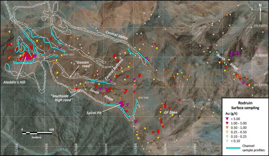
Figure 1: Surface sampling plan of the Rodruin prospect, with showing location of individual point samples and channel sample profiles, and drill access roads and pads
Drilling commenced at Aladdin’s Hill at the western end of the Rodruin prospect (see Figure 2). Surface rock chip sampling of highly altered rocks at Aladdin’s Hill has returned an average grade at surface of 3.75 g/t Au (see news release dated September 4, 2018), and drill hole ROP-003 testing this zone has returned an intersection of 36m @12.47 g/t Au (see news release dated October 1, 2018). Surface channel sampling around Aladdin’s Hill, as well as other areas (see Figures 1 and 2), has recently returned significant and wide mineralised intersections including 65.3m @ 2.84 g/t Au and 5.26% Zn from gossanous carbonates and slates (see news release dated September 24, 2018), indicating the potential development of mineralisation over a wide area away from the main workings at Aladdin’s Hill. Visible gold in highly altered rocks has also been identified in outcrop at Aladdin’s Hill, as well as other areas, including the Spiral Pit.
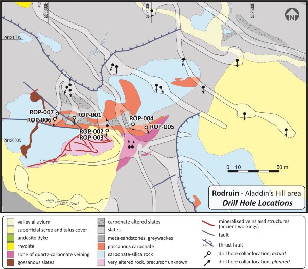
Figure 2: Schematic geological plan of the Aladdin’s Hill area, showing locations of drill holes ROP-001 to ROP-007
Results of drill holes ROP-004 to ROP-007
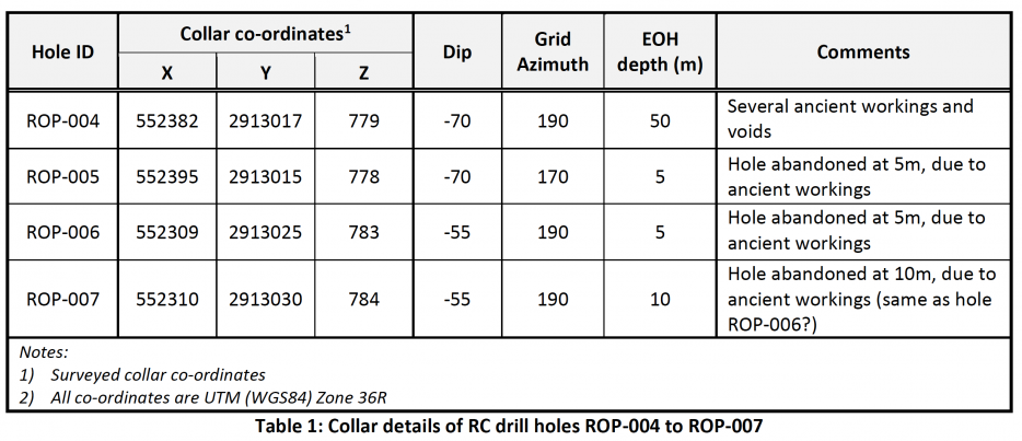
Assay results are now available for the drill holes ROP-004 to ROP-007, which were all drilled on a southerly orientation around the margins of the main Aladdin’s Hill workings (see Figure 2) to test gossan-hosted mineralisation mapped at surface. Details of the collar locations are provided in Table 1. 3 of the 4 holes intersected ancient workings very near to surface, with these holes being abandoned at depths of between 5 and 10m, but hole ROP-003 returned a significant mineralised intersection from surface. Mineralisation was intersected in all 4 holes, and details of the gold-zinc mineralised intersections are provided in Table 2.
All 4 holes targeted zones of gossan-hosted mineralisation on the margins of the main ancient workings at Aladdin’s Hill, and intersected gold-zinc (-silver) mineralisation. Hole ROP-004 to the east of Aladdin’s Hill returned a significant intersection of 38m @ 1.84 g/t Au from surface (see Table 2). This hole also intersected several narrow voids, believed to be ancient underground mine workings and stopes. Hole ROP-005 intersected mineralisation from surface, increasing in grade before a large void was hit at 4m, which could not be drilled through. Furthermore the large pad from which holes ROP-004 and ROP-005 were drilled had to be abandoned, due to the presence of previously unidentified workings and voids only a couple of metres below ground level.
Holes ROP-006 and ROP-007 were drilled on the westernmost pad at Aladdin’s Hill, and were designed to test gossanous carbonate-hosted mineralisation. Hole ROP-006 was abandoned at 5m after intersecting a large underground void, but intersected mineralisation from surface. The rig was stepped back, and hole ROP-007 was collared behind ROP-006 but this again intersected a large void, presumed to be depth extension of that in ROP-006, and again had to be abandoned. Encouragingly this drill hole intersected 2 metres of high grade mineralisation, on the margins of the underground stope.
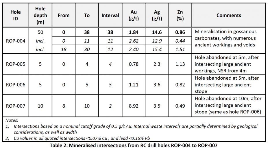
While it was clearly disappointing that 3 of the latest holes were unable to penetrate through substantial and hitherto unmapped ancient underground workings, their presence is nonetheless encouraging and indicative of gold mineralisation in gossanous carbonate rocks at Rodruin, as anticipated. Hole ROP-004 intersected significant gold mineralisation from surface, and the confirmation of gold mineralisation in this material from drill holes is most encouraging as large areas of gossanous material have been mapped at surface on the South Ridge at Rodruin. The results from the latest batch of drill holes adds credence to the Company’s belief that drilling will intersect significant mineralisation over wide areas of the South Ridge at Rodruin, and that these broad zones are also likely to carry significant high grade zones within them. The results of the initial drilling, as well as access road and pad construction, are also confirming significant structural complexity at Rodruin, as mapped at surface, with significant dislocation of mineralised zones (see Figure 3). Aton is actively working to open up mineralisation over as large an area as is possible for drill testing in the ongoing Phase 1 RC programme.
Activity Update
Construction of drill access roads and pads is ongoing at Rodruin to support the current Phase 1 RC drilling programme. New drill pads have been constructed at the Spiral Pit (see Figure 3), and on the “gossan road” high on the Central Buttress of the South Ridge. One of the excavators onsite is now progressing towards the GF Zone, some 500m SE of Aladdin’s Hill to open up another large area of gossanous mineralisation mapped at surface for drill access (see Figure 1).
Sampling of channel profiles ROC-018 to ROC-022, to test mineralisation exposed in access roads (see Figure 1), has now been completed. Initial assay results are expected from these profiles shortly, and it is expected that these will help to define further mineralisation at surface, away from the immediate Aladdin’s Hill area. Further mineralisation has been exposed in new access roads, including a lower road below the “gossan road” (see Figure 1), which is progressing towards the Central Buttress to allow access for drill testing a large area of mapped gossan and ancient workings on the Central Buttress.
Drilling was temporarily suspended at Rodruin in late September, due to various mechanical problems with the rig, and issues with drill hole surveying. Capital have worked diligently to resolve all these issues, and drilling is now back underway again.
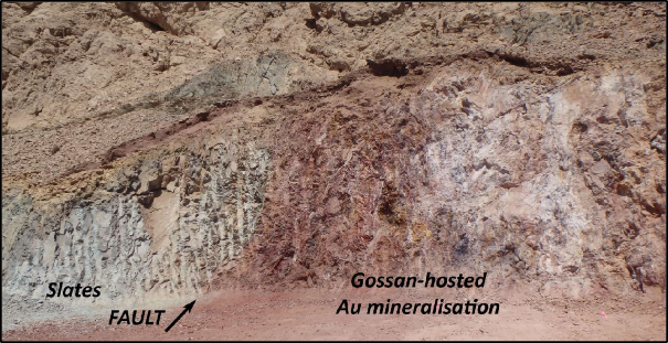
Figure 3: Fault truncating gossan-hosted mineralisation below the Spiral Pit in new drill pad. The entrance to the Spiral Pit, which appears to follow several structures including the one pictured above, and has returned assays including 35.3 g/t and 20.6 g/t Au, is visible immediately above the fault. The gossan-hosted mineralisation returned a surface intersection of 24m @ 2.27 g/t Au in channel sample profile ROC-017 immediately to the SE of this fault, and is overlain and largely covered at surface by unmineralised carbonate seen in the top and top left of the photo. This carbonate unit comprises the overthrust block, above the main thrust fault mapped in Figure 2.
Drilling and sampling procedures
Drill holes were drilled at c. 140mm diameter, and the bulk percussion chip samples were collected directly into large plastic bags from the cyclone every metre, numbered with the hole number and hole depths by the drill crew, and laid out sequentially at the drill site. RC chips were logged onsite by a senior Aton geologist. The bulk 1m samples were weighed, and subsequently riffle split through a 3-tier splitter onsite by Aton field staff to produce an approximately 1/8 split, which was collected in cloth bags, numbered and tagged with the hole number and depth. The reject material from this initial bulk split was re-bagged, labelled and tagged, and the bulk reject samples will be stored and retained on site at Rodruin. A representative sample of each metre was washed, stored in marked plastic chip trays, each containing 20m of samples, photographed, and retained onsite as a permanent record of the drill hole (see Figure 4).
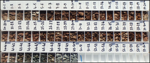
Figure 4: Composite image of the ROP-004 chip trays. Mineralisation can be seen to be associated with weathered and gossanous carbonate rocks (brown), which occur to a depth of 41m before the hole passes into green altered slates
All the 1m split samples were weighed again, and the samples selected for assay were riffle split onsite, typically a further 3-4 times using a smaller lab splitter, to produce a nominal c. 250-500g sample split for dispatch to the assay laboratory. All samples were sent for assay from holes ROP-004 to ROP-007. The laboratory splits were allocated new sample numbers. QAQC samples were inserted into the sample runs dispatched to the assay laboratory at a nominal rate of 1 duplicate sample for every 10 drill samples, 1 blank sample every 10 samples, and 1 standard sample of a certified reference material every 40 samples. Reject material from the 1m samples after the laboratory split had been taken, and any unused 1m splits will be retained at the Company’s Hamama laboratory for future reference purposes, as and when required.
The selected c. 250-500g split samples were shipped to ALS Minerals at Rosia Montana, Romania for analysis. Samples were analysed for gold by fire assay with an atomic absorption spectroscopy (“AAS”) finish (analytical code Au-AA23); and silver, copper, lead and zinc with an aqua regia digest followed by an AAS finish (analytical code AA45). High grade gold samples (>10 g/t Au) were re-analysed using analytical code Au-AA25 (also fire assay with an AAS finish). High grade Ag and base metal samples (Ag >100 g/t, and Cu, Pb, and Zn >10,000ppm or >1%) were re-analysed using the ore grade technique AA46 (also an aqua regia digest followed by an AAS finish).
Rodruin
The Rodruin prospect was discovered in December 2017 by Aton geologists (see news release dated December 14, 2017), and is located approximately 18km east of the Company’s Hamama West mineral deposit (see Figure 5). Field mapping and sampling has indicated the presence of ancient mine workings and extensive gold mineralisation over an area of at least 700m x 400m at surface. Abundant visible gold has been identified in hand specimens from surface outcrops, and ancient dumps and underground workings, with individual selective grab samples assaying up to 321 g/t Au. The main series of extensive ancient underground workings in the Aladdin’s Hill area has also been sampled to a depth of approximately 40m below ground level, indicating continuation of the surface mineralisation at depth (see news releases dated February 6, 2018, March 5, 2018 and April 16, 2018), and drilling has now confirmed the presence of high grade gold mineralisation with individual samples returning assays of up to 221 g/t Au over metre intervals. Underground workings at the Spiral Pit have been sampled to a depth of 12-15m below ground level, returning assays of up to 35.3 g/t Au and 37.9% Zn (see news release dated August 7, 2018).
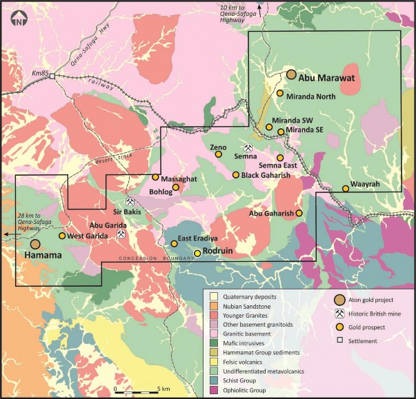
Figure 5: Abu Marawat regional geology, showing the location of the Rodruin prospect
About Aton Resources Inc.
Aton Resources Inc. (AAN: TSX-V) is focused on its 100% owned Abu Marawat Concession (“Abu Marawat”), located in Egypt’s Arabian-Nubian Shield, approximately 200km north of Centamin’s Sukari gold mine. Aton has identified a 40km long gold mineralised trend at Abu Marawat, anchored by the Hamama deposit in the west and the Abu Marawat deposit in the east, containing numerous gold exploration targets, including three historic British mines. Aton has identified several distinct geological trends within Abu Marawat, which display potential for the development of RIRG and orogenic gold mineralisation, VMS precious and base metal mineralisation, and epithermal-IOCG precious and base metal mineralisation. Abu Marawat is over 738km2 in size and is located in an area of excellent infrastructure; a four-lane highway, a 220kV power line, and a water pipeline are in close proximity.
Qualified Person
The technical information contained in this News Release was prepared by Javier Orduña BSc (hons), MSc, MCSM, DIC, MAIG, SEG(M), FGS, Exploration Manager of Aton Resources Inc. Mr. Orduña is a qualified person (QP) under National Instrument 43-101 Standards of Disclosure for Mineral Projects.
For further information regarding Aton Resources Inc., please visit us at www.atonresources.com or contact:
Mark Campbell
President and Chief Executive Officer Tel: +202-27356548
Email: mcampbell@atonresources.com
Note Regarding Forward-Looking Statements
Some of the statements contained in this release are forward-looking statements. Since forward-looking statements address future events and conditions; by their very nature they involve inherent risks and uncertainties. Actual results in each case could differ materially from those currently anticipated in such statements.
Neither TSX Venture Exchange nor its Regulation Services Provider (as that term is defined in policies of the TSX Venture Exchange) accepts responsibility for the adequacy or accuracy of this release.