Aton intersects 40m @ 1.30 g/t Au and 11m @ 5.20 g/t Au in drill hole ROP-032 at the Central Buttress Zone, further extending the mineralised footprint at Rodruin
Vancouver, January 3, 2019: Aton Resources Inc. (AAN: TSX-V) (“Aton” or the “Company”) is very pleased to provide investors with a further update on the latest results from the Phase 1 reverse circulation percussion (“RC”) drilling and surface channel sampling programmes at its advanced Rodruin prospect, within the Company’s 100% owned Abu Marawat Concession (“Abu Marawat” or the “Concession”), located in the Eastern Desert of Egypt.
Highlights:
- Final assay results have now been received from a further 7 drill holes, ROP-030 to ROP-036, at Rodruin (see Figure 1), with all holes intersecting gold mineralisation. Hole ROP-030 was drilled at Aladdin’s Hill, holes ROP-031 to ROP-034 were drilled high on the Central Buttress Zone (“CBZ”) of the South Ridge, ROP-035 was drilled behind the Spiral Pit, and ROP-036 was collared at the GF Zone (“GFZ”);
- Holes ROP-031 to ROP-034 on the upper CBZ all intersected significant widths of gold mineralisation at, or from very near to surface. ROP-032 was mineralised from surface to the end of hole, and intersected 40m @ 1.30 g/t Au and 13.5 g/t Ag from surface, and 11m @ 5.20g/t Au and 23.0 g/t Ag from 59m depth, with individual samples grading up to 20.6 g/t Au;
- Other holes on the upper CBZ returned gold mineralised intersections including 31m @ 2.45 g/t Au and 12.5 g/t Ag from 2m depth (hole ROP-034), 34m @ 2.00 g/t Au from 10m (hole ROP-033), and 40m @ 0.64 g/t Au from 11m (hole ROP-031);
- Drill hole ROP-030 on the southern side of the main ancient workings at Aladdin’s Hill was consistently mineralised and returned an intersection of 47m @ 1.72 g/t Au from surface;
- Channel sample profile ROC-023 returned a mineralised intersection of 33.6m @ 1.59 g/t Au at surface from the GFZ.
“These exemplary results are a great way to start out 2019, and continue to expand the footprint of the gold mineralisation drilled from and at surface at Rodruin” said Mark Campbell, President and CEO. “Having discovered Rodruin only 13 months ago, we have come a long way and these drilling results continue to confirm our view of Rodruin as having the potential to become a large bulk minable gold project comprising wide zones of good mineralisation exposed from surface, with higher grade shoots contained within. We are looking forward to beginning the next phase of our exploration drilling programme at Rodruin as well as at some of the 17 other exploration targets within our Concession. I believe that 2019 will be a landmark year for Aton.”
RC drilling and surface channel sampling at Rodruin
Assay results from latest 7 drill holes, ROP-030 to ROP-036, of the Phase 1 RC drilling programme at Rodruin are now available (see Table 1 for collar details). Full details of the gold mineralised intervals from these holes are shown in Table 2. Hole ROP-030 was drilled on the southern flank of Aladdin’s Hill, holes ROP-031 to ROP-034 were drilled high on the CBZ, ROP-035 was drilled behind the Spiral Pit, and ROP-036 was collared at the GFZ (see Figure 1). Additionally one further surface channel sample profile, ROC-023, has been completed at the ROP-036 drill pad, at the GFZ.
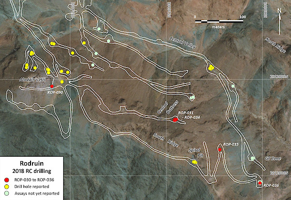
Figure 1: Phase 1 drill hole collar plan of the Rodruin project, showing locations of all holes completed (road layout as of December 5, 2018)
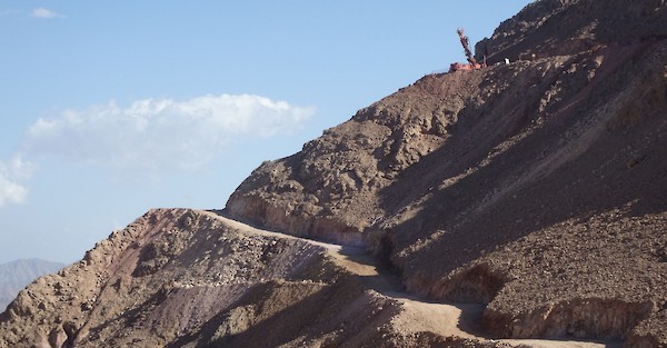
Figure 2: Drill rig set up on hole ROP-033 high on the Central Buttress Zone, viewed from the northwest
| Hole ID | Collar co-ordinates 1 | Dip | Grid azimuth | EOH depth (m) | Comments | ||
|---|---|---|---|---|---|---|---|
X | Y | Z | |||||
ROP-030 | 552360 | 2912987 | 781 | -55 | 275 | 75 | Aladdin’s Hill |
ROP-031 | 552619 | 2912917 | 803 | -90 | n/a | 51 | Upper Central Buttress Zone |
ROP-032 | 552620 | 2912917 | 803 | -55 | 110 | 70 | Upper Central Buttress Zone |
ROP-033 | 552616 | 2912915 | 803 | -55 | 180 | 80 | Upper Central Buttress Zone |
ROP-034 | 552618 | 2912915 | 803 | -55 | 150 | 95 | Upper Central Buttress Zone |
ROP-035 | 552710 | 2912855 | 763 | -55 | 245 | 50 | Behind and below the Spiral Pit |
ROP-036 | 552797 | 2912785 | 742 | -90 | n/a | 15 | GF Zone |
Notes:
| |||||||
Table 2: Collar details of RC drill holes ROP-030 to ROP-036
| Hole ID | Length (m) | Intersection (m) 1 | Au (g/t) | Ag (g/t) | Zn (%) | Comments | ||
|---|---|---|---|---|---|---|---|---|
From | To | Interval | ||||||
ROP-030 | 75 | 0 | 47 | 47 2 | 1.72 | 4.0 | 0.42 | South side of Aladdin’s Hill main workings |
incl. | 3 | 23 | 20 | 2.85 | 5.5 | 0.12 | ||
and incl. | 27 | 41 | 14 | 1.28 | 2.8 | 0.37 | ||
ROP-031 | 51 | 11 | 51 | 40 2, 3 | 0.64 | 3.6 | 0.07 | Upper CBZ, hole collapsing, abandoned at 51m, NSR4 due to void/workings from 17-22m |
incl. | 15 | 33 | 18 | 0.92 | 3.6 | 0.10 | ||
and incl. | 49 | 51 | 2 | 1.26 | 8.1 | 0.08 | ||
ROP-032 | 70 | 0 | 40 | 40 | 1.30 | 13.5 | 0.19 | Upper CBZ, hole collapsing, with voids/workings from 63m |
and | 59 | 70 | 11 | 5.20 | 23.0 | 0.29 | ||
ROP-033 | 80 | 3 | 6 | 3 | 0.75 | 2.3 | 0.04 | Upper CBZ, drilling to south |
and | 10 | 44 | 34 | 2.00 | 8.5 | 0.13 | ||
ROP-034 | 95 | 2 | 33 | 31 | 2.45 | 12.5 | 0.10 | Upper CBZ, drilling to southeast |
and | 49 | 52 | 3 | 4.41 | 22.1 | 0.12 | ||
ROP-035 | 50 | 0 | 9 | 9 2 | 0.54 | 2.3 | 0.58 | Drilling from behind Spiral Pit |
ROP-036 | 15 | 0 | 15 | 15 2 | 0.62 | 3.8 | 0.14 | GFZ, hole terminated at 15m |
Notes:
| ||||||||
Table 2: Mineralised intersections from drill holes ROP-030 to ROP-036
Upper Central Buttress Zone
Holes ROP-031 to ROP-034 were collared from a single drill pad high on the CBZ on the northern flank of the South Ridge (see Figures 1-3), with angled holes collared towards the east, southeast and south, as well as a single vertical hole. There is only limited access in this area, due to the steep topography on the South Ridge, and the difficulty of constructing drill pads in the very hard outcropping carbonates (see Figure 2). Surface channel sample profile ROC-019 returned an intersection of 26.3m @ 2.29 g/t Au from this pad, and channel sampling inside ancient underground mine workings at this pad also returned short high grade intersections of 4.8m @ 12.00 g/t Au and 4.9m @ 4.10 g/t Au (see news release dated October 29, 2018).
All 4 holes drilled intersected significant widths of mineralisation associated with weathered and gossanous carbonate rocks. Hole ROP-031 was vertical and had to be abandoned at 51m due to it collapsing, after intersecting several voids between 11-30m, including a significant ancient underground working with no sample recovery (“NSR”) between 17-22m. The hole returned an overall intersection of 40m @ 0.64 g/t Au and 3.6 g/t Ag from 11m depth to the end of hole (“EOH”). Zero grade was assigned to the NSR zone, which in reality underscores the presumed high grade of this zone prior to it being extracted by the ancient miners. The highest individual gold grades from this hole were adjacent to the NSR zone. Grades were again increasing towards EOH, before it had to be abandoned, possibly indicating the presence of a deeper higher grade zone, not fully tested in this hole.
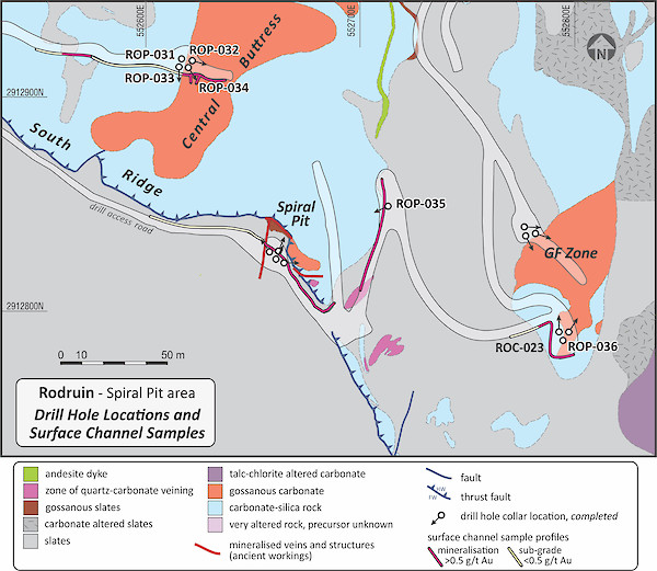
Figure 3: Schematic geological plan of the Spiral Pit Zone, the upper CBZ and the GFZ, including drill holes ROP-031 to ROP-036, and channel sample profile ROC-023
Hole ROP-032 was collared towards the east, and had to be abandoned in strong mineralisation at 70m after hitting several voids, presumed to be associated with a zone of partially backfilled workings, between 63m and EOH. ROP-032 was mineralised from surface to the end of the hole, returning 40m @ 1.30 g/t Au and 13.5 g/t Ag from surface, and a deeper high grade intersection of 11m @ 5.20 g/t Au and 23.0 g/t Ag from 59m to EOH, associated with the zone that had apparently been partially exploited by the ancient miners. Gold grades were again increasing in the final 4m, to >20 g/t Au between 68-69m.
Holes ROP-033 and ROP-034 were collared towards the south and the southeast respectively, both intersecting mineralisation in gossanous carbonates. Both holes terminated as planned in unmineralised sediments. Hole ROP-033 intersected 34m @ 2.00 g/t Au and 8.5 g/t Ag from 10m depth, and ROP-034 intersected 31m @ 2.45 g/t Au and 12.5 g/t Ag from 2m depth. These 4 drill holes confirm that the outcropping mineralisation at this drill pad is open at least to the south, east and north, and is not closed off in any of these directions. The mineralisation remained open at depth in holes ROP-031 and ROP-032.
Hole ROP-035 was drilled to the northeast of the Spiral Pit (see Figures 1 and 3) to follow up on surface mineralisation in surface channel profile ROC-018 (58.2m @ 1.25 g/t Au, see news release dated October 29, 2018), and intersected low grade mineralisation, with an intercept of 9m @ 0.54 g/t Au and 0.58% Zn from surface.
GF Zone
The GFZ is located approximately 500m east-southeast of the main workings at Aladdin’s Hill, and is expressed at surface as a series of dark chocolate brown gossanous carbonates, again with abundant ancient workings. Drill hole ROP-036 was collared from a drill pad at the top of the outcropping zone of gossan, and this pad was also sampled at surface in channel sample profile ROC-023 (see Figure 3).
Hole ROP-036 was terminated at 15m, short of its planned depth, intersecting 15m @ 0.62 g/t Au over the entire length of the hole, in gossanous carbonates and massive white quartz veins. Channel sample profile ROC-023 returned a surface mineralised intersection of 33.6m @ 1.59 g/t Au, 3.6 g/t Ag and 0.62% Zn between 14m and the end of the profile, again associated with the outcropping gossanous carbonates.
Aladdin’s Hill
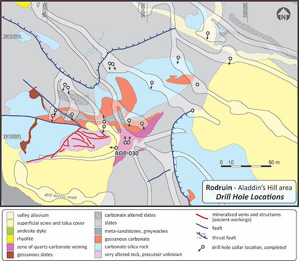
Figure 4: Schematic geological plan of the Aladdin’s Hill area, showing the location of drill access roads and pads, and drill hole ROP-030
A single hole ROP-030 was completed on the southern side of the main ancient underground workings at Aladdin’s Hill (see Figures 1 and 4). The hole was collared towards the west, and was designed to test mineralised and altered sediments in channel sample profile ROC-005, which returned 64.9m @ 2.29 g/t Au at surface (see news release dated September 12, 2018). Hole ROP-030 intersected 47m @ 1.72g/t Au, 4.0 g/t Ag, 0.31% Cu and 0.42% Zn from surface, in a sequence of quartz-sericite-iron oxide phyllic altered sediments.
Discussion
This latest tranche of drilling results again expands the wider footprint of the Au-Ag-Zn mineralisation at Rodruin away from the initially tested Aladdin’s Hill area, and continues to confirm the presence of near surface mineralisation over a wide area of the South Ridge at Rodruin.
The results of the first drill holes ROP-031 to ROP-034, on the upper CBZ, are particularly encouraging with significant widths of gossan-hosted mineralisation intersected in a new zone, similar to that drilled at the Spiral Pit Zone (see news release dated December 10, 2018). Work is ongoing to construct an access road linking these 2 zones, and to expose potential additional surface mineralisation. This mineralisation remains open over a wide area, and at depth in holes ROP-031 and ROP-032. The high grade intersection of 11m @ 5.20 g/t Au and 23.0 g/t Ag between 59m to EOH in hole ROP-031 is again most encouraging in that it continues to suggest the potential for shoots and zones of higher grade gold mineralisation within the overall Rodruin mineralised area. Drilling from another pad below and to the northeast of holes ROP-031 to ROP-034 on the CBZ (see Figure 1) has also intersected gossanous and mineralised carbonates and ancient workings to depths of up to 80m downhole, although all assays for these holes remain pending.
The preliminary drilling at the GFZ is also encouraging with sub-surface mineralisation confirmed from the prematurely terminated hole ROP-036. A further 5 deeper holes have also been completed at the GFZ, all of which hit gossan-hosted mineralisation from surface, although assays are again pending.
Once again gold mineralisation has been intersected in all of the latest batch of drill holes, which continues to provide strong encouragement to Aton. The primary objective of the Phase 1 RC drilling programme was to identify and test the distribution of near surface gold mineralisation over the South Ridge at Rodruin, and this latest tranche of results continues to expand the near surface mineralised footprint at Rodruin, and adds to Aton’s belief that Rodruin represents a significant new greenfields gold discovery in Egypt. Much of the near surface mineralisation at Rodruin away from Aladdin’s Hill appears to be associated with gossanous carbonate host rocks, while the sulphide mineralisation hosted in altered dolomitic carbonates intersected in hole ROP-017 (163m @ 0.90 g/t Au from surface, see news release dated November 12, 2018) indicates a potential primary equivalent of the near surface mineralisation. Encouragingly, a further wide zone of carbonate-hosted base metal sulphide mineralisation has also been intersected in the final drill hole ROP-050 from the Phase 1 programme, with assays again awaited.
Following a short shutdown over Christmas and New Year Aton intends to re-start field activities including the construction of access roads and drilling positions at Rodruin in January 2019, ahead of the second phase of drilling.
Rodruin
The Rodruin prospect was discovered in December 2017 by Aton geologists (see news release dated December 14, 2017), and is located approximately 18km east of the Company’s Hamama West mineral deposit. Field mapping and sampling has indicated the presence of ancient mine workings and extensive gold mineralisation over an area of at least 700m x 400m at surface. Mineralisation is associated with a sequence of carbonate and metasedimentary slate and greywacke rock types. Abundant visible gold has been identified in hand specimens from surface outcrops, and ancient dumps and underground workings, with individual selective grab samples assaying up to 321 g/t Au (see news releases dated February 6, 2018, March 5, 2018 and April 16, 2018). Drilling has now confirmed the presence of high grade gold mineralisation at Aladdin’s Hill with individual samples returning assays of up to 221 g/t Au over metre intervals (see news release dated October 1, 2018). Drilling results released to date from Rodruin include intersections of 36m @ 12.47 g/t Au from 5m (hole ROP-003 at Aladdin’s Hill, see news release dated October 1, 2018), 20m @ 5.36 g/t Au (hole ROP-029 at the Spiral Pit, see news release dated December 10, 2018), and 163m @ 0.90 g/t Au from surface (hole ROP-017 northeast of Aladdin’s Hill, see news release dated November 12, 2018).
Sampling and analytical procedures
Drill samples
Drill holes were drilled at 140mm diameter, and the bulk percussion chip samples were collected directly into large plastic bags from the cyclone every metre, numbered with the hole number and hole depths by the drill crew, and laid out sequentially at the drill site. RC chips were logged onsite by a senior Aton geologist. The bulk 1m samples were weighed, and subsequently riffle split through a 3-tier splitter onsite by Aton field staff to produce an approximately 1/8 split, which was collected in cloth bags, numbered and tagged with the hole number and depth. The reject material from this initial bulk split was re-bagged, labelled and tagged, and the bulk reject samples will be stored and retained on site at Rodruin. A representative sample of each metre was washed, stored in marked plastic chip trays, each containing 20m of samples, photographed, and retained onsite as a permanent record of the drill hole.
All the 1m split samples were weighed again, and the samples selected for assay were riffle split onsite, typically a further 3-4 times using a smaller lab splitter, to produce a nominal c. 250-500g sample split for dispatch to the assay laboratory. The laboratory splits were allocated new sample numbers. QAQC samples were inserted into the sample runs dispatched to the assay laboratory at a nominal rate of 1 duplicate sample for every 10 drill samples, 1 blank sample every 10 samples, and 1 standard sample of a certified reference material every 40 samples. Reject material from the 1m samples, after the laboratory split had been taken, and any unused 1m splits will be retained at the Company’s Hamama facility for future reference purposes, as and when required.
Channel samples
Access road cuttings and drill pads selected for channel sampling initially had their exposed faces cleaned by an excavator, prior to sampling. A single continuous sample channel was cut along each profile using a large, generator powered angle grinder. Sample intervals were marked up on the cleaned faces with spray paint, with the start and end points of individual samples marked on the exposed faces. An aluminium tag was also hammered into the sample profile to mark the position and number of each sample. The channels were created by sawing 2 parallel cuts, approximately 50-75mm apart, with the angle grinder. The cut channel was subsequently sampled using a hammer and chisel, with the sampled material excavated from between the 2 cuts. The profiles were sampled at nominal 2m intervals, but with individual sample lengths varying from less than 1m to greater than 3m, as appropriate. Samples were collected and bagged up in cloth bags, and crushed to -4mm at Aton’s onsite Hamama sample preparation laboratory, and split to a nominal c. 250-500g sample size.
Assay procedures
The selected c. 250-500g drill and channel samples were shipped to ALS Minerals at Rosia Montana, Romania for analysis. Samples were analysed for gold by fire assay with an atomic absorption spectroscopy (“AAS”) finish (analytical code Au-AA23); and silver, copper, lead and zinc with an aqua regia digest followed by an AAS finish (analytical code AA45). High grade gold samples (>10 g/t Au) were re-analysed using analytical code Au-AA25 (also fire assay with an AAS finish). High grade Ag and base metal samples (Ag >100 g/t, and Cu, Pb, and Zn >10,000ppm or >1%) were re-analysed using the ore grade technique AA46 (also an aqua regia digest followed by an AAS finish).
About Aton Resources Inc.
Aton Resources Inc. (AAN: TSX-V) is focused on its 100% owned Abu Marawat Concession (“Abu Marawat”), located in Egypt’s Arabian-Nubian Shield, approximately 200km north of Centamin’s Sukari gold mine. Aton has identified a 40km long gold mineralised trend at Abu Marawat, anchored by the Hamama deposit in the west and the Abu Marawat deposit in the east, containing numerous gold exploration targets, including three historic British mines. Aton has identified several distinct geological trends within Abu Marawat, which display potential for the development of RIRG and orogenic gold mineralisation, VMS precious and base metal mineralisation, and epithermal-IOCG precious and base metal mineralisation. Abu Marawat is over 738km2 in size and is located in an area of excellent infrastructure; a four-lane highway, a 220kV power line, and a water pipeline are in close proximity.
Qualified person
The technical information contained in this News Release was prepared by Javier Orduña BSc (hons), MSc, MCSM, DIC, MAIG, SEG(M), FGS, Exploration Manager of Aton Resources Inc. Mr. Orduña is a qualified person (QP) under National Instrument 43-101 Standards of Disclosure for Mineral Projects.
For further information regarding Aton Resources Inc., please visit us at www.atonresources.com or contact:
MARK CAMPBELL
President and Chief Executive Officer
Tel: +202-27356548
Email: mcampbell@atonresources.com
Note Regarding Forward-Looking Statements
Some of the statements contained in this release are forward-looking statements. Since forward-looking statements address future events and conditions; by their very nature they involve inherent risks and uncertainties. Actual results in each case could differ materially from those currently anticipated in such statements.
Neither TSX Venture Exchange nor its Regulation Services Provider (as that term is defined in policies of the TSX Venture Exchange) accepts responsibility for the adequacy or accuracy of this release.