Aton Announces Results Of Surface Sampling At The Semna Prospect, With Intersections Of Up To 9.7m @ 5.17 G/t Gold Returned From Channel Sample Profiles
Vancouver, November 22, 2017: Aton Resources Inc. (AAN: TSX-V) (“Aton” or the “Company”) is pleased to provide investors with an update on exploration activities at the Semna and East Eradiya prospects, currently underway at the Company’s 100% owned Abu Marawat concession (“Abu Marawat” or the “Concession”), located in the Eastern Desert of Egypt.
Highlights:
- Channel and grab sampling at the Semna prospect has returned assays of 18.05 g/t Au from individual channel samples and intersections of up to 9.7m @ 5.17 g/t Au from channel sample profiles, and assays up to 10.8 g/t Au from grab samples;
- Field inspection of the East Eradiya prospect has revealed the presence of hitherto unreported and unknown ancient workings on a very extensive scale, largely obscured by alluvial wadi sediments;
- A deep ground penetrating radar geophysical survey has recently been undertaken and completed over the Waayrah, Miranda VMS, Abu Gaharish, Sir Bakis, Semna, Bohlog and East Eradiya prospects, with encouraging preliminary results.
Mark Campbell, President and CEO of Aton stated: “Results from the area around the old Semna mine are extremely encouraging. I believe that we have identified a large and significant gold deposit. We will be planning on drilling this soon after West Garida. These results and the exciting new discovery of the hitherto unrecognised ancient workings at East Eradiya, just continue to confirm the huge overall potential of the Abu Marawat Concession area. Our recent two year time extension means that the potential to make multiple large commercial discoveries increases significantly.”
Semna Prospect
The Semna prospect is located approximately 27km ENE of the Company’s Hamama West mineral deposit (see Figure 1), and is accessed via desert tracks from either Hamama or the Abu Marawat deposit to the north. The Semna area has a long history of gold mining, during both ancient and modern times. There is archaeological evidence in the area suggesting that mining took place during the early Arab, Ptolemaic, and New Kingdom periods, and possibly dates back to as far as the Old Kingdom period, over 4,500 years ago. In modern times, Semna was exploited by the British between 1904-1906 by two companies, the Eridia (Egypt) Exploring Company Limited and Fatira (Egypt) Exploring Company Limited, that worked the Main Vein on two underground levels. By about 1908 however, the British gold mining industry in Egypt had been almost totally eclipsed by the discovery of oil, and was more or less moribund. There was also some further development work of Semna in the 1950s by a subsidiary of the Egyptian Phosphate Company. It has been reported that the Semna mine had the widest vein exploited during the British era of mining in Egypt, which reached up to 6m width in places, and the British reported mining grades of over 2 ounces per ton. Reports from the British Mining Journal from 1905 indicated that some pillars within the ancient stopes assayed up to 5.5 ounces per ton gold.
The mineralisation at Semna is hosted in a heterogeneous quartz diorite body that has been intruded into a package of metasediments with BIF horizons, which outcrop to the west and north of the main Semna mine area. Recent mapping has identified small bodies of outcropping pink granites, probably related to the Younger Granite suite, approximately 750m south of the mine workings. There are 4 distinct mineralized zones – the Main Vein and the South Vein have been the primary focus of historic mining, but there are also workings developed on the North Vein and the Central Veins zone (see Figure 2). The mineralization is strongly structurally controlled, and the mineralization is hosted in a series of steeply dipping shear zones that contain the gold-bearing quartz veins. These sub-parallel quartz veins strike approximately east-west and dip 60-70° to the south, but the dip and strike is quite variable within each vein, and the veins noticeably pinch and swell. The auriferous quartz veins carry significant amounts of accessory sulphide minerals, and are typically quite gossanous and rich in iron oxides at surface, as a response to weathering. Levels of copper are elevated, notably in the Main and North Veins.

Figure 1: Abu Marawat regional geology, showing the location of the Semna and East Eradiya prospects
The Company has recently completed a programme of surface sampling over the Semna area collecting a total of 313 samples (see Figure 2). Of these 278 were collected from a series of channel profiles, and 35 were point samples, either grab or short chip channel samples. Channel samples were manually taken using a hammer and chisel, and were collected over nominal 2m intervals perpendicular to potential mineralization, but their lengths were adjusted according to relevant geological controls and features. Samples were dispatched to ALS Minerals at Rosia Montana, Romania for gold fire assay analysis with analytical code AA-Au23 (repeated by AA-Au25 for samples which returned gold grades greater than 10 g/t Au). Widespread gold mineralization at surface was identified from this sampling programme.
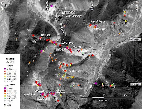
Figure 2: Surface sample and channel profile sampling plan of the Semna project
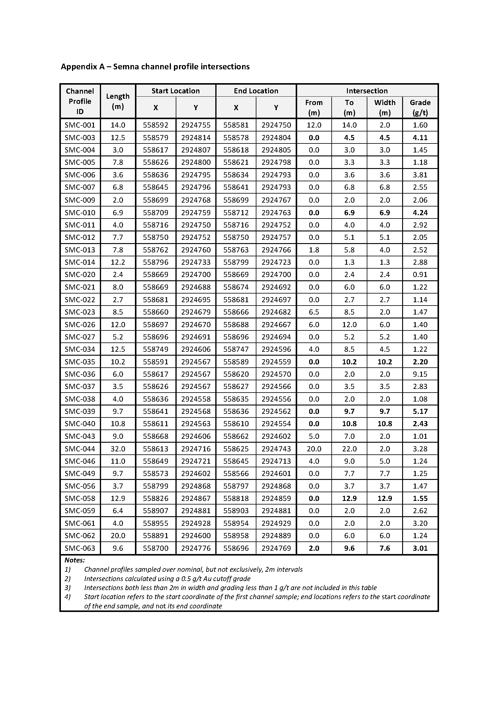
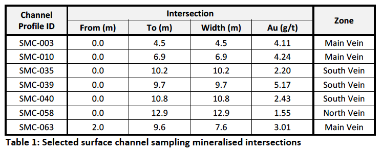
The 63 channel sample profiles varied between 2m and 32m, averaging 8m, in length. Of the 278 samples collected, 69 (or 25% of the samples) returned assays of greater than 1 g/t Au, of which 16 samples returned assays greater than 5 g/t Au (6% of the samples). Mineralization was identified in almost all the profiles sampled, and surface channel sample intersections were returned from all the areas sampled (Figure 2). Mineralized intersections included 9.7m @ 5.17 g/t Au (from channel SMC-039 on the South Vein), 6.9m @ 4.24 g/t Au (from channel SMC-010 on the Main Vein), and 12.9m @ 1.55 g/t Au (from channel SMC-058 on the North Vein). A selection of the intersections is tabulated below in Table 1, and all surface intersections are presented in Appendix A.
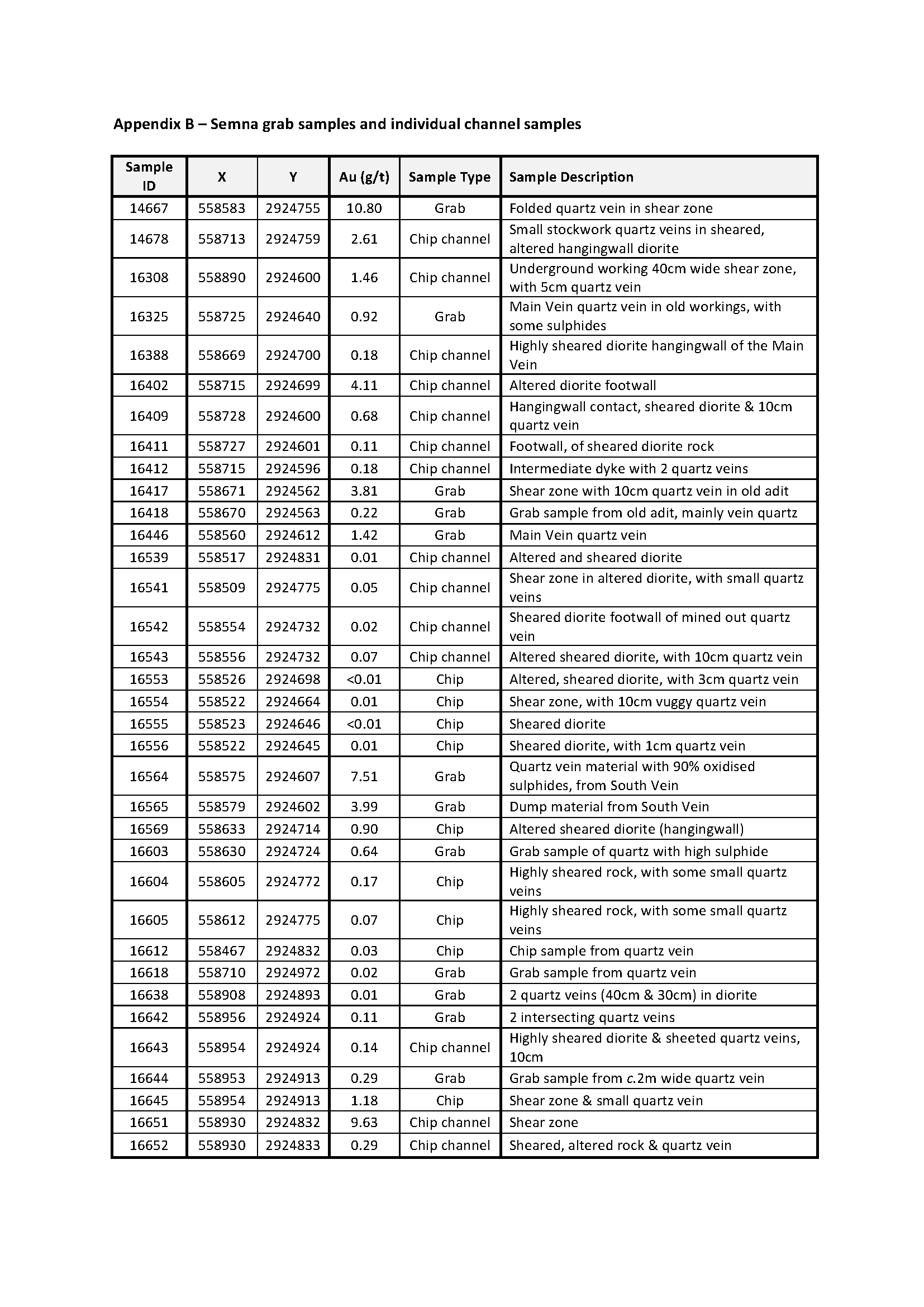
Of the 35 grab and individual channel samples, 10 (or 29% of the samples) returned assays of greater than 1 g/t Au, of which 3 samples returned assays greater than 5 g/t Au (9% of the samples), up to a maximum of 10.8 g/t Au from a folded and sheared quartz vein. Results of all grab and individual channel samples are presented in Appendix B.
East Eradiya Prospect
The north zone, the main area of interest at East Eradiya is located approximately 1000m to the east of the Eradiya granite pluton (see Figure 1), in a broad area of low relief and was identified from satellite imagery which indicated a large area of scattered ancient buildings and ancient workings (see Figure 3). Initial inspection of the imagery suggested that the workings were washing sites and no signs of mining were identified. Earlier field inspection of a previously identified site, the south zone, about 0.7 km to the SE had suggested the presence of ancient processing waste only and no evidence of in situ extraction. Follow-up field inspection of the north zone indicated the presence of large amounts of processing waste from ancient mining activity, and the main area of interest is littered with crater-like dumps with distinctive bowl shaped hollows in their centers (see Figure 4), which initially appeared to be washing sites. However, on closer inspection some of these appear to contain the remains of inclined shafts and several possible crown holes were identified. The sites of at least three shafts are clear, but piles of excavated spoil are widespread and probably indicate further shafts. Crown holes away from the shafts indicate that underground workings are extensive and the amount of surface spoil is very significant compared to other ancient mining sites in the area, again suggesting the ancient workings are very extensive. The whole area is covered by a thin veneer of alluvial debris which largely obscures the underlying geology, but around the shafts this can be seen to be less than 1m thick.

Figure 3: East Eradiya prospect (modified from Google Earth)
From the very limited exposure it is clear that the ancient miners were targeting quartz reefs hosted by a shallowly eastward dipping shear zone. The sheared rock is highly weathered and appears to have been intensely hydrothermally altered. Two sets of quartz veins are visible, one sub-vertical, and the other set of veins dipping parallel to the fabric of the shear zone. The vein quartz is heavily copper-stained with supergene chrysocolla and malachite, and limonite after sulphides. From the limited exposures and the surface topography the shear zone would appear to sub-crop over an area a little under 500m long and 180m wide, striking NNE. Other ancient workings have been identified to the west of the East Eradiya, close to the granite contact. The host rock appears to be a tuffaceous andesitic unit, mostly comprising lapilli tuffs.
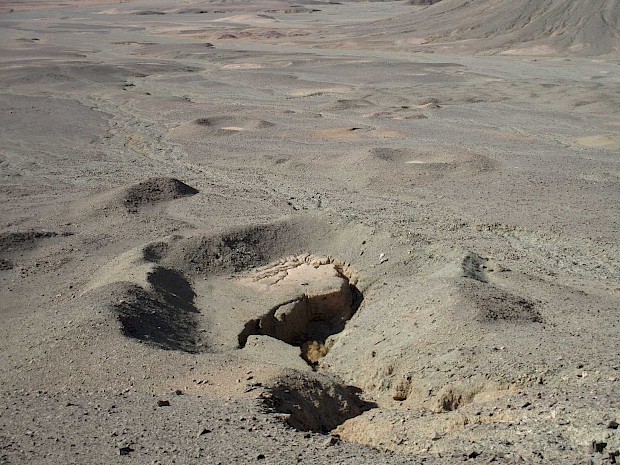
Figure 4: Ancient workings at the East Eradiya north zone prospect (the water erosion feature in the nearest pit appears to be an old shaft)
Following the identification of extensive ancient workings in the area a programme of deep ground penetrating radar geophysical profiling has been carried out at the East Eradiya north zone. Surface trenching is also planned to expose the mineralised structures to allow mapping and sampling at East Eradiya.
Activity update:
- Metallurgical testwork on the four 120kg bulk composite samples of oxide and transitional mineralised material from the Hamama West deposit delivered to Wardell Armstrong International in the UK is well underway, and preliminary coarse bottle roll and agitated leach tests on the samples have been completed with encouraging results. The crushed metallurgical samples are currently undergoing percolation and agglomeration testing, after which the column leach tests will be expected to be started shortly.
- Cube Consulting have commenced work on a revised mineral resource estimate for the Hamama West deposit. This revision will incorporate the results of the spring 2017 drilling programme, and will include also results from the Crocs Nose Zone to the south-west of the Hamama West Main Zone, which was not included in the maiden mineral resource estimate.
- A deep ground penetrating radar geophysical survey has recently been undertaken and completed over the Waayrah, Miranda VMS, Abu Gaharish, Sir Bakis, Semna, Bohlog and East Eradiya prospects, with encouraging preliminary results. The programme was undertaken by Terravision Exploration of the UK, industry leaders in the provision of deep GPR services to the mining and exploration sector. Detailed interpretation of the results is underway, and it is anticipated that the final report on this programme will be completed within the next month.
- Further sampling programs have now been completed over several of the regional target areas, including the Sir Bakis, Abu Gaharish, Bohlog and Massaghat prospects, and results from these sampling programs will be reported shortly.
About Aton Resources Inc.
Aton Resources Inc. (AAN: TSX-V) is focused on its 100% owned Abu Marawat Concession (“Abu Marawat”), located in Egypt’s Arabian-Nubian Shield, approximately 200 km north of Centamin’s Sukari gold mine. Aton has identified a 40 km long gold mineralized trend at Abu Marawat, anchored by the Hamama deposit in the west and the Abu Marawat deposit in the east, containing numerous gold exploration targets, including three historic British mines. Aton has identified several distinct geological trends within Abu Marawat, which display potential for the development of RIRG and orogenic gold mineralization, VMS precious and base metal mineralization, and epithermal-IOCG precious and base metal mineralization. Abu Marawat is over 738km2 in size and is located in an area of excellent infrastructure, a four-lane highway, a 220kV power line, and a water pipeline are in close proximity.
Qualified Person
The technical information contained in this News Release was prepared by Roderick Cavaney BSc, MSc (hons), MSc (Mining & Exploration Geology), FAusIMM, SEG, GSA, SME, Vice President, Exploration, of Aton Resources Inc. Mr. Cavaney is a qualified person (QP) under National Instrument 43-101 Standards of Disclosure for Mineral Projects.
For further information regarding Aton Resources Inc., please visit us at www.atonresources.com or
contact:
Mark Campbell
President and Chief Executive Officer
Tel: +1-936-689-2589
Email: mcampbell@atonresources.com
Note Regarding Forward-Looking Statements
Some of the statements contained in this release are forward-looking statements. Since forward-looking statements address future events and conditions; by their very nature they involve inherent risks and uncertainties. Actual results in each case could differ materially from those currently anticipated in such statements.
Neither TSX Venture Exchange nor its Regulation Services Provider (as that term is defined in policies of the TSX Venture Exchange) accepts responsibility for the adequacy or accuracy of this release.